Wednesday, October 13, 2010

Dora Canal - Eustis Florida

The Dora Canal connects Lake Eustis with Lake Dora. It was originally called the Elfin River. In the late 1800s the river was dredged so that watercraft could more easily move through it.

We were only in central Florida for a short time, visiting relatives. In the mid 1980s to the early 1990s, we often took boat rides down the canal when we visited Kathy's parents. Her father still lives on a canal off Lake Eustis, but it has been quite awhile since he has owned a boat.

The Dora Canal is only about a mile long, but one has the opportunity to have a shot at seeing just about all of the wildlife species that live in central Florida. I had a little bit of time to spare while traveling from one relative's home to another, so I parked my car at the bridge over Highway 441 and walked under the bridge to the canal.


Lake Eustis and the Dora Canal


Bridge Over the Doral Canal at Highway 441


Its only possible to walk a short way down the canal. The underbrush gets thick in a hurry.


The Dora Canal


Huge Bamboo


This trailer is not quite "move in ready." Several more abandoned trailers are scattered about near the entrance to the canal. A few decades ago, one could leave very cheap on waterfront like this - not now.


The little speck on the water at the left is an alligator. On the right is a partly sunken boat.


A Closer Look at the Alligator


Some of the plants on the canal are probably remnants of old home sites.


Ospry


Wednesday, October 6, 2010

Ute Rock Art - Arches National Park

When we were at Arches National Park near Moab, Utah, we followed a path to these petroglyphs. They aren't real old. They picture horse and rider along with bighorn sheep. Petroglyphs are just etches in rock, so the only way to date them is subject matter. Horses didn't get to North American until the Europeans arrived, so this rock art can't date any farther back than the 1600s. They are the work of the Utes who gave the state of Utah its name.


Tuesday, October 5, 2010

Moab Utah Rock Shop

On our last trip to Utah we made the long drive from Salt Lake City to Moab to visit Arches National Park. When we left the park we stopped by this rock shop.


The rocks were interesting, but what got my attention were the prehistoric Indian artifacts that were for sale. I do remember back when I was kid seeing boxes of arrowheads at tourists stops and attractions, but we don't see Indian artifacts for sale at those places in the South nowadays.

The shop glued magnets on these pottery shards. I wouldn't do that. The fact they'd market authentic prehistoric Indian artifacts as refrigerator magnets illustrates how much of it can easily be found out West.


Here is part of a display case full of Indian artifacts - big pottery shards, tools, hammerstones, manos, metates ... The store even had boxes of flakes and chips for sale, kinda like the boxes of shells in our coastal souvenir shops.


Leading in and out of the shop, were (legit)dinosaur tracks.


Monday, August 16, 2010

Antelope Island - Utah

Last week we were in Salt Lake City visiting our son and his wife Laurie. Since we had never been to Utah, wading in the Great Salt Lake was on our list of things to do. The day after we arrived, Chris took us to Antelope Island State Park, which we found to be a great place to see a nice part of the Great Salt Lake. Antelope island is the largest of the Salt Lake's nine islands.

Chris and Laurie had visited the island twice, without seeing any antelope. Not so this time - we saw two. These are skittish, shy creatures that do not allow you to get too close. I got close enough to take a photo of the second one we saw. The Great Salt Lake is in the background.


The American bison (which most people just call buffalo) are less shy. They are actually very easy to get close to - close enough to be unsafe. At Yellowstone National Park, more people are killed or injured by bison than they are by bears. There are about 600 bison on Antelope Island.


Wading in the lake was fun. We didn't see any fish jumping (since there aren't any). The only life under the water is brine shrimp. Plenty of ducks and birds are on top of the water feeding on the shrimp. The Great Salt Lake is six times saltier than ocean water.


Chris and I were the only ones who felt like hiking that day. It was hot, but not "Alabama thick humidity" hot. We walked up Buffalo Point, about a 20-minute steep climb.


Few places I have been were as a quiet as Buffalo Point. We only passed two hikers on the way up and a couple more on the way down. There were no boats on the lake, no planes in the sky. Just silence.


On the way out of the park, we stopped at the visitors center for this photo-op.

Sunday, July 11, 2010

Rocky Mountain National Park
Snow in July

Last week I was in Colorado, and on Thursday July 8, I visited Rocky Mountain National Park. I only mention the date because it was snowing in the mountains. I forgot my sweater, and I was wearing a short sleeved shirt. I was the only one in the mountains that I saw who wasn't wearing a coat. Two people thought they were doing the right thing by telling me that I wasn't wearing one.

Before getting to Estes Park, I stopped to watch this person trout fish in the Big Thompson River. Notice the beaver den across the river.


I bypassed Estes Park. I love the town but I wanted to see as much scenery in the park as I could in the few hours that I had.

At the Highway 34 bypass, I stopped to take a photo of these ladies at their painting party.


They were painting just across the across from the Stanley Hotel.


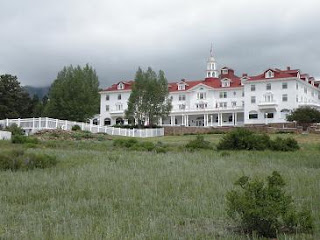
The Stanley Hotel was built about 100 years ago and many believe it is haunted. It was the inspiration for Stephen King's the Shining. Parts of the movie was filmed at the Stanley.

Upon entering the park, I drove towards Trail Ridge Road. I wanted to get into the higher elevations to find snow. Before Trail Ridge, I parked at the Hidden Valley area to take a short walk along the creek.


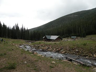
Up until the last several decades, Hidden Valley was a ski resort. It closed when winters got warmer, and there was less snow at its elevation. Now it is a picnic and hiking area.

From Hidden Valley, I quickly drove into much higher elevations, and it got cold in a hurry. I snapped this picture while driving.


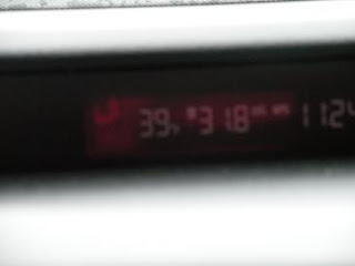
The time is wrong, but the temperature is correct - 39. It had been snowing off and on all day. Trail Ridge Road was closed for awhile earlier in the day until a snow plow could clear the road.

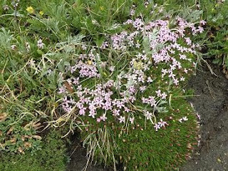
I stopped at the Rock Cut area to take a short walk and take some photos.


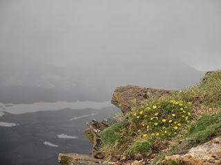
It always amazes me that flowers can bloom in such a harsh environment.


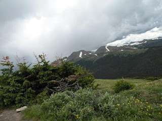
After getting back on Trail Ridge Road, I didn't get far before traffic backed up. The road was being resurfaced, and it was about twenty minutes before traffic began moving again. There are worse places than Rocky Mountain National Park to be "stuck." I wouldn't have noticed this alpine lake if I had not been forced to wait.


Once traffic began moving again, I made my to Milner Pass at the Continental Divide, where water flows two ways - to the Pacific or to the Atlantic.


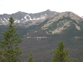
Not far from Milner Pass is Never Summer Mountains, the only volcanic mountain range in Rocky Mountain National Park.


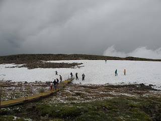
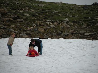
It was getting late in the day, and I had to return my rental car by six. So I headed back towards Fort Collins, stopping to take a couple photos of these people enjoying the snow. A ramp was constructed to keep people of the fragile tundra. I suppose rocks are underneath the snow.


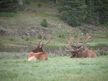
I thought I had hit more road construction, but it was only an animal sighting.


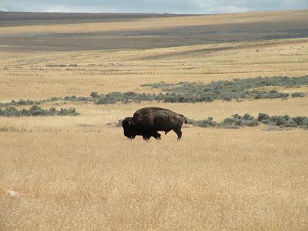
There is no better place in the world than Rocky Mountain National Park to see elk, but these bulls were all I saw on this day. At lower elevations, especially in the winter, it is the norm to see herds of elk.